The Easy Transform software is developed for user-friendly bidirectional transformation of spatial coordinates between selected coordinate systems. It is designed for MS Windows in Czech language version.
The software works with the following coordinate systems:
1. WGS84
World Geodetic System 1984.
2. ETRS89 / ETRF89
European Terrestrial Reference System 1989 using the European Terrestrial Reference Frame 1989.
3. ETRS89 / ETRF2000
European Terrestrial Reference System 1989 using the European Terrestrial Reference Frame 2000.
4. Bessel
System of spatial coordinates on the Bessel ellipsoid.
5. S-JTSK / Bessel
Datum of Uniform Trigonometric Cadastral Network (S-JSTK) with ellipsoidal heights above the Bessel ellipsoid
6. S-JTSK / Bpv
Datum of Uniform Trigonometric Cadastral Network (S-JSTK) with heights in the Baltic Vertical Datum (Bpv).
Transformation methods used by the software are described below:
1. A method of global transformation parameters
This method is used for coordinate transformation between the WGS84 ellipsoid system and the Bessel ellipsoid system. It is based on a spatial similarity transformation using the global transformation parametres (rotation, translation and scaling;
Fig. 2). The software allows to edit these parametres. For example the user can set local parametres thus achieve the more accurate local transformation.
2. A transformation by identical points
This method is used for coordinate transformation between the ETRS89/ETRF89 system and the S-JTSK/Bpv system. The transformation is realized with the use of identical points, which have the coordinates known in both systems. The software provides more than 3000 identical points situated throughout the Czech Republic. Points are taken from the database of minor control points, which is managed by Czech Office for Surveying, Mapping and Cadastre (valid until January 2, 2011).
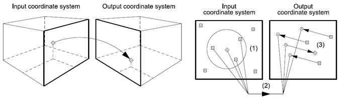
The software allows to set a frame (around the transform point), wherein the identical points are applied. In this way it is possible to control the number of the identical points which are included in the calculation.
3. A new ETRS89 realization in the Czech Republic
A new realization of the European Terrestrial Reference System 89 entered into force in the Czech Republic on January 2, 2011. This realization results in a transition from the previously used frame ETRF89 to the new frame ETRF2000. The transformation between the ETRS89/ETRF2000 system and the S-JTSK/Bpv system is carried out according to a new methodology. It is based on applying the Datum of Uniform Trigonometric Cadastral Network 2005 (S-JTSK/05).
The software uses the revised transformation parameters valid in the Czech Republic since August 1, 2012. It follows the recommendations of the Czech Office for Surveying, Mapping and Cadastre.
The point coordinates can be transformed in two ways. The first is an one-point method for transfromation of individual points (Fig. 1, the right part). The second is a mutli-point method, which allows to transform more points loaded from a text file (Fig. 3).
Download
The Easy Transform software is provided only for scientific and educational purposes, i.e. it cannot be used for commercial purposes.
The software (including demonstration data) download link below:
Easy Transform CZ


